Sor-Varanger
This is your travel guide for Sor-Varanger, Tromssan ja Finmarkun, Norway
1 : Visit Vardo Fortress [2 hrs]
Explore the well-preserved Vardo Fortress, which dates back to the 1300s and offers stunning views of the Barents Sea. Learn about its role in Norwegian history and its strategic importance during various conflicts. Don’t miss the underground tunnels and exhibits showcasing the fortress’s rich heritage.
2 : Birdwatching at Hornoya Island Nature Reserve [3 hrs]
Take a boat trip to Hornoya Island Nature Reserve, a haven for seabirds such as puffins, guillemots, and kittiwakes. Observe the diverse bird species in their natural habitat and enjoy the peaceful surroundings. Capture amazing photos of the seabird colonies and scenic landscapes on the island.
Background Info
Weather
Sor-Varanger experiences cold temperatures, with winter lows around -10°C and summer highs around 15°C. Rainfall is moderate, and humidity levels vary. Air quality is generally good in this remote area.
Language
The local language spoken in Sor-Varanger is Norwegian.
Sør-Varanger Municipality – municipality in Finnmark, Norway
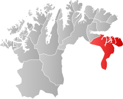
Location: Sor-Varanger, Tromssan ja Finmarkun , Norway![]()
Official Site: Visit Official Site
Summary: Sør-Varanger Municipality Summary
Map: Map of Sør-Varanger Municipality
Weather: Sør-Varanger Municipality Forecast
Official Languages: Bokmål
Local Names: Sør-Varanger kommune (BokmÃ¥l), Sør-Varanger kommune (Nynorsk), Mátta-Várjjaga gielda (Northern Sami), Etelä-Varankin kunta (Kven), Saujj-Vaʹrjjel kåʹdd (Skolt Sami)
Population: 10,227 (2016)
Area: 3,968 sq km
Coordinates: 69.729, 30.042
Timezone: (UTC+01:00) Central European Time (Oslo)


