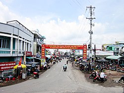
Huyen Chau Thanh
This is your travel guide for Huyen Chau Thanh
1 : Visit Gáo Giong Eco-Tourism Park [2 hrs]
Explore the wetland area, take a boat ride to see the diverse flora and fauna, visit the bird sanctuary, and learn about local conservation efforts at this ecotourism park.
2 : Experience the Cao Lanh Floating Market [1 hr]
Witness the vibrant atmosphere of this traditional market where local vendors sell fruits, vegetables, and other goods from their boats. Engage in the lively bargaining culture and taste local specialties like fresh fruits and seafood.
Background Info
Weather
Huyen Chau Thanh experiences a tropical climate with average temperatures ranging from 25°C to 32°C. The region has a high humidity level with occasional rainfall throughout the year. Air quality may vary depending on seasonal factors.
Language
The local language spoken in Huyen Chau Thanh is Vietnamese.
Cost Of Living
The cost of living index in Huyen Chau Thanh is lower compared to urban areas in Vietnam, making it an affordable destination for travelers.
Other
Huyen Chau Thanh is known for its agricultural production, particularly rice cultivation, and offers a glimpse into rural Vietnamese life.
Châu Thành – district south of Đồng Tháp province
Location: Huyen Chau Thanh, Đồng Tháp , Viet Nam![]()
Summary: Châu Thành Summary
Map: Map of Châu Thành
Weather: Châu Thành Forecast
Elevation: 3 m
Area: 234 sq km
Coordinates: 10.258, 105.874
Timezone: (UTC+07:00) Indochina Time (Ho Chi Minh City)

