Happy Valley
This is your travel guide for Happy Valley, Redding, California, United States
1 : Visit Whiskeytown National Recreation Area [2 hrs]
Explore the crystal-clear waters of Whiskeytown Lake, go hiking on the various scenic trails such as Crystal Creek Falls, and learn about the history of the Old Shasta ghost town.
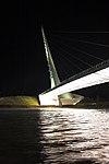
2 : Discover the Sundial Bridge at Turtle Bay Exploration Park [1 hr]
Marvel at Santiago Calatrava’s stunning pedestrian bridge, which spans the Sacramento River, visit the botanical gardens, and enjoy interactive exhibits at Turtle Bay Exploration Park.
3 : Experience the beauty of Lassen Volcanic National Park [3-4 hrs]
Witness steaming fumaroles, mud pots, and hot springs at Bumpass Hell, hike to the top of the volcanic crater of Lassen Peak, and drive the scenic highway for breathtaking views.
4 : Attend the Turtle Bay Easter Egg-Stravaganza [2 hrs]
Join in the festive Easter egg hunt, take photos with the Easter Bunny, enjoy live entertainment, and participate in fun-filled activities for the whole family.
5 : Explore the Shasta State Historic Park [1-2 hrs]
Step back in time to Gold Rush-era California, tour the historic courthouse, jail, and general store, and learn about the region’s rich history through exhibits and guided tours.
Background Info
Weather
Happy Valley enjoys a Mediterranean climate with hot, dry summers and mild, wet winters. Summer temperatures can reach highs of 90°F (32°C), while winter temperatures can drop to around 30-40°F (0-4°C). Rainfall is more prevalent in the winter months, with occasional snowfall.
Language
English is the predominant language spoken in Redding and the surrounding areas.
Cost Of Living
The cost of living in Redding is slightly below the national average, making it a relatively affordable place to live. Housing costs, groceries, and transportation are all generally lower compared to other parts of California.
Redding – city in Shasta County, California, United States
Location: Happy Valley, Redding, California 96001, United States of America![]()
Official Site: Visit Official Site
Summary: Redding Summary
Map: Map of Redding
Weather: Redding Forecast
Post Codes: 96001–96003, 96049, 96099, 96001, 96002, 96003
Dialing Codes: 530
Official Names: Redding (English)
Local Names: Redding (English)
Population: 89,861 (2010)
Elevation: 172 m
Area: 158.442 sq km
Coordinates: 40.586, -122.392
Timezone: (UTC-08:00) Pacific Time (Los Angeles)


