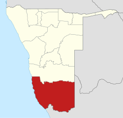
Keetmanshoop
This is your travel guide for Keetmanshoop, Namibia
1 : Visit the Giant’s Playground Nature Reserve [2 hrs]
Explore the otherworldly rock formations that resemble a giant’s playground, created by millions of years of erosion. Enjoy hiking trails, birdwatching opportunities, and stunning panoramic views of the surrounding landscape.
2 : Discover the Quiver Tree Forest [1.5 hrs]
Marvel at the unique and iconic quiver trees, a species of aloe that can grow up to 9 meters tall. Learn about the traditional uses of these trees by the San people and capture stunning photographs at sunset when the trees glow in the golden light.
3 : Explore the Naute Dam [1.5 hrs]
Visit the largest reservoir in Namibia, the Naute Dam, surrounded by picturesque scenery and offering various water-based activities such as fishing, boating, and birdwatching. Take a leisurely walk along the dam wall or enjoy a peaceful picnic overlooking the water.
4 : Walk through the Christ Church [1 hr]
Admire the historical architecture of the Christ Church, a Lutheran church built in 1895 with a design reminiscent of a castle. Explore the interior, including stained glass windows and wooden pews, and learn about the church’s significance in the community.
5 : Shop at the Keetmanshoop Craft Market [1 hr]
Browse locally crafted souvenirs, handmade jewelry, traditional clothing, and unique Namibian artworks at the Keetmanshoop Craft Market. Interact with local artisans, haggle for prices, and support the local economy by purchasing authentic handicrafts.
Background Info
Weather
Keetmanshoop experiences hot desert-like weather with temperatures reaching up to 40°C (104°F) in summer and dropping to around 5°C (41°F) in winter. Rainfall is scarce, with occasional short but heavy showers between November and February. Humidity levels are generally low, and air quality is good due to the remote location.
Language
The official language of Namibia is English, with Afrikaans and German also widely spoken in Keetmanshoop due to its colonial history. Indigenous languages such as Khoekhoegowab and Oshiwambo are also commonly used among different ethnic groups.
Cost Of Living
The cost of living in Keetmanshoop is relatively low compared to major cities in developed countries, with affordable accommodation, dining, and transportation options. However, prices may vary depending on the season and availability of goods due to the town’s remote location.
Other
Keetmanshoop serves as a gateway to the famous Fish River Canyon, one of the largest canyons in the world. The town is known for its traditional Nama culture, friendly locals, and stunning desert landscapes, making it a unique destination for nature lovers and outdoor enthusiasts.
Karas Region – Region of Namibia
Location: Keetmanshoop, //Karas , Namibia![]()
Official Site: Visit Official Site
Summary: Karas Region Summary
Map: Map of Karas Region
Weather: Karas Region Forecast
Official Languages: English
Population: 77,421 (2011)
Area: 161,395 sq km
Coordinates: -26.567, 18.133
Timezone: (UTC+02:00) Central Africa Time (Windhoek)

