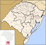
Lajeado
This is your travel guide for Lajeado, municipality of Rio Grande do Sul, Brazil
1 : Visit Lagoa da Harmonia Park [2 hrs]
Explore the picturesque Lagoa da Harmonia Park, known for its serene lake surrounded by lush greenery. Enjoy a leisurely walk around the park’s well-maintained trails and spot local wildlife like birds and butterflies. Take a relaxing boat ride on the tranquil lake or have a scenic picnic with family and friends.
2 : Tour the Lajeado Historical Museum [1.5 hrs]
Immerse yourself in the rich history of Lajeado at the Historical Museum, showcasing artifacts and exhibits detailing the area’s cultural heritage. Learn about the early settlers, indigenous peoples, and the development of the region through engaging displays and guided tours. Browse through old photographs, documents, and interactive displays that bring the past to life.
3 : Explore the Convent of the Immaculate Conception [1 hr]
Visit the Convent of the Immaculate Conception, a historic site known for its stunning architecture and religious significance. Admire the beautiful chapel, ornate decorations, and peaceful atmosphere of this spiritual retreat. Learn about the nuns who once lived here and the convent’s role in the local community.
4 : Shop at the Lajeado Ecological Park Fair [1.5 hrs]
Discover local crafts, fresh produce, and handmade goods at the Lajeado Ecological Park Fair, a vibrant market held regularly in the city. Browse through stalls selling artisanal products, organic foods, and unique souvenirs while enjoying the lively atmosphere. Taste traditional Brazilian treats, interact with friendly vendors, and support the local economy by purchasing authentic goods.
5 : Attend the Lajeado Oktoberfest [3 hrs]
Join the lively festivities of the Lajeado Oktoberfest, a traditional German festival celebrated with music, dances, food, and beer. Experience the lively atmosphere of the event, with colorful parades, folk performances, and exciting competitions throughout the day. Indulge in delicious German cuisine, sample a variety of beers, and dance to the sounds of live bands playing festive tunes.
Background Info
Weather
Lajeado experiences a temperate climate with warm summers and cool winters. Average temperatures range from 18°C to 28°C during the summer months and 5°C to 18°C in winter. Rainfall is evenly distributed throughout the year, with occasional thunderstorms. Humidity levels are moderate, offering comfortable conditions for outdoor activities. Air quality is generally good in Lajeado.
Language
The official language spoken in Lajeado is Portuguese. English may not be widely spoken, so it is helpful to know basic Portuguese phrases for communication.
Cost Of Living
The cost of living in Lajeado is relatively affordable compared to major cities in Brazil. Housing, transportation, and food prices are reasonable, making it a cost-effective destination for travelers. Local markets and street vendors offer budget-friendly options for shopping and dining.
Other
Lajeado is known for its strong agricultural sector, with a focus on soybean and maize production. The city hosts various cultural events and festivals throughout the year, showcasing its rich heritage and vibrant community spirit. Lajeado’s proximity to natural attractions like parks and lakes provides opportunities for outdoor recreation and eco-tourism activities.
Lajeado – municipality of Rio Grande do Sul, Brazil
Location: Lajeado, Rio Grande do Sul , Brazil![]()
Official Site: Visit Official Site
Summary: Lajeado Summary
Map: Map of Lajeado
Weather: Lajeado Forecast
Post Codes: 95900-001 até 95914-999
Dialing Codes: 51
Population: 71,445 (2010)
Elevation: 32 m
Area: 91.16 sq km
Coordinates: -29.467, -51.961
Timezone: (UTC-03:00) Brasilia Time (Sao Paulo)


