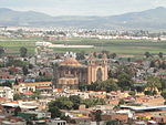
San Andres Cholula
This is your travel guide for San Andres Cholula
1 : Visit the Great Pyramid of Cholula [2 hrs]
Explore the largest pyramid in the world by volume, buried under a hill in Cholula. Enjoy the panoramic views from the top and learn about the history and significance of this archaeological site.
2 : Tour the Ex-Convento de San Gabriel [1.5 hrs]
Discover the beautiful former convent with its impressive architecture and intricate details. Visit the museum inside to see religious art and artifacts from the region’s history.
3 : Stroll through the Plaza de la Concordia [1 hr]
Walk around the historic square lined with colorful buildings, cafes, and shops. Admire the colonial architecture and relax in the peaceful atmosphere of this charming area.
4 : Visit the Church of Santa Maria Tonantzintla [1 hr]
Marvel at the Baroque-style church known for its ornate indigenous-inspired decorations. Admire the intricate plasterwork and colorful designs that cover the interior of this unique religious site.
5 : Explore the Regional Ceramic Museum [1.5 hrs]
Discover the art and history of traditional Talavera ceramics in this museum. See a wide range of pottery pieces and learn about the techniques and cultural significance of this craft.
Background Info
Weather
San Andres Cholula experiences a temperate climate with average temperatures ranging from 55°F (13°C) in the winter to 77°F (25°C) in the summer. Rainfall is highest in the summer months, with occasional thunderstorms. Humidity levels vary throughout the year. Air quality is generally good.
Language
Spanish is the primary language spoken in San Andres Cholula.
Cost Of Living
The cost of living in San Andres Cholula is lower than in many major cities in Mexico, making it an affordable destination for travelers. Housing, transportation, and food costs are generally reasonable.
San Andrés Cholula Municipality – human settlement in Mexico
Location: San Andres Cholula, Puebla, Puebla , Mexico![]()
Map: Map of San Andrés Cholula Municipality
Weather: San Andrés Cholula Municipality Forecast
Population: 137,290 (2015)
Elevation: 2150 m
Area: 61 sq km
Coordinates: 19.021, -98.292
Timezone: (UTC-06:00) Central Time (Mexico City)


