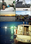
Tabatinga
This is your travel guide for Tabatinga, Amazonas, Brazil
1 : Visit Comara Beach [2 hrs]
Enjoy the serene sandy beaches alongside the Amazon River at Comara Beach. Relax under the shade of palm trees, take a refreshing swim in the river’s waters, or simply admire the picturesque views of the surrounding jungle and the river’s flow.
2 : Explore Tabatinga Municipal Market [1 hr]
Immerse yourself in the local culture by browsing through the Tabatinga Municipal Market. Discover a variety of fresh fruits, vegetables, handicrafts, and traditional Amazonian products. Interact with local vendors, taste exotic fruits, and shop for unique souvenirs to take back home.
Background Info
Weather
Tabatinga experiences a tropical rainforest climate with high temperatures year-round averaging around 80-90°F (27-32°C). The region receives abundant rainfall, particularly from December to May, with high humidity levels and generally good air quality.
Language
The primary language spoken in Tabatinga is Portuguese, reflecting Brazil’s official language. However, due to its location near the borders of Peru and Colombia, Spanish is also commonly understood and spoken.
Cost Of Living
Tabatinga has a relatively low cost of living compared to major Brazilian cities, with affordable prices for accommodation, food, and transportation. The cost of living index is significantly lower than metropolitan areas in Brazil, making it an attractive destination for budget travelers.
Tabatinga – municipality in Amazonas, Brazil
Location: Tabatinga, Amazonas , Brazil![]()
Summary: Tabatinga Summary
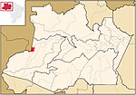
Map: Map of Tabatinga
Weather: Tabatinga Forecast
Dialing Codes: 97
Population: 37,919 (2000)
Elevation: 102 m
Area: 3,224.875 sq km
Coordinates: -4.253, -69.938
Timezone: (UTC-04:00) Amazon Standard Time (Manaus)


